
Initial Publication Date: 12/1/2014
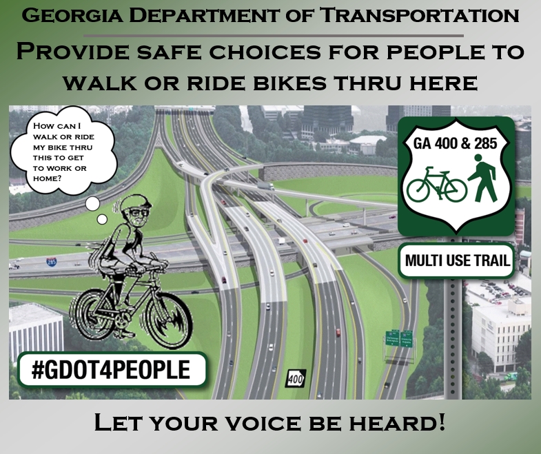
Georgia Department of Transportation: Let’s have safe human-powered transportation choices, connecting transit nodes, medical facilities, employees, residents, employment and commercial centers across & through the barriers known as Georgia 400 & I-285.
GDOT Project info site here: Combined Project Info Website
Our Asks:
#1: GDOT Build Trails / Multi-Use Paths along both SR-400 & I-285. (National Examples below)
#2: Complete Streets “Best Practices” on all on-street segments of the projects (intersections, underpasses, bridges). Go above & beyond a simple 4-ft wide bike lane with a white painted stripe – (Examples below). Don’t mix bikes & peds on the same facility.
#3: Bring Georgia Bikes, PEDS & Advocates to the planning table. Let us review the designs & have input.
Sign the On-Line Petition
Click HERE
Environmental Review Process
Please go to this PAGE to understand how the process works. GDOT has to go through the US Federal Highway Administration to receive final approval, based on Environmental impacts. Click HERE to review & understand.
A Picture Speaks a Thousand Words:
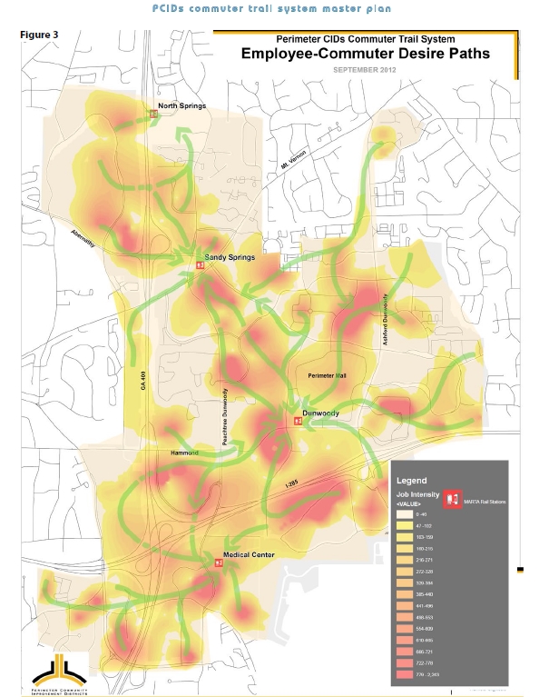
Perimeter CIDs Employee-Commuter Desire Paths. Accommodate human-powered transportation choices across & through these concrete barriers known as Georgia 400 & I-285.
Reference: Perimeter CIDs Bike/Ped Trail Plan.
Update as of 5/29/2015:
AWESOME NEWS: Trail to be included along GA-400 through I-285 interchange!
As reported in the Neighbor Newspapers on May 29th, the Georgia Department of Transportation as agreed to have a trail included along GA-400 through I-285 interchange! Many thanks go to the City of Sandy Springs for committing $1 Million towards the trail. Specific thanks also go to the PATH Foundation, Perimeter CIDs (in support of their Trail Plan), and the Cities of Dunwoody, Brookhaven, Chamblee, Doraville and many civic organizations and the business community for their support.
More details click HERE
Update as of 5/10/2015: The Georgia Division of the Southern Environmental Law Center has submitted a formal letter to GDOT referencing legal reasoning to support accommodating bicycle and pedestrian users of the adjacent roadway within these projects.

For a copy of their letter, please click here: SELC – GDOT letter – Bike Ped Accommodation on 285-400 Interchange
Update as of 4/22/2015: The Georgia Department of Transportation (GDOT) has agreed to review a proposal presented by PATH and other bicycle and pedestrian advocates to make provisions for the PATH400 Trail through the new I-285/Georgia 400 interchange project!!
![]()
For more details, checkout the update on the PATH Foundation’s website HERE.
Update as of 4/21/2015: The Doraville City Council voted on March 16th to endorse a resolution in support of having the Georgia Department of Transportation provide trail accommodation & applying Complete Streets designs for the $1 Billion dollar I-285/SR-400 Interchange project.

To download, click here: Doraville PATH_Resolution0001
Update as of 3/17/2015: The Chamblee City Council voted unanimously to endorse a resolution in support of having the Georgia Department of Transportation provide trail accommodation & applying Complete Streets designs for the $1 Billion dollar I-285/SR-400 Interchange project.
![]()
To download, click here: Chamblee Resolution of Support
Update as of 3/9/2015: The Dunwoody City Council voted to endorse a resolution in support of trails & applying Complete Streets designs for the $1 Billion dollar I-285/SR-400 Interchange project.
![]()
To download, click here: Dunwoody Resolution GA400 Trail Ext
Update as of 3/4/2015: Children’s Healthcare of Atlanta Resolution of support.
![]()
To download, click here: CHOA Letter of Support
Update as of 2/19/2015: City of Brookhaven Resolution of support.
![]()
To download, click here: Brookhaven Resolution20150202Trails
Update as of 2/4/2015 – Part II: Sandy Springs Perimeter Chamber of Commerce Resolution of support.

To download, click here: SSPC – RESOLUTION IN SUPPORT OF Trails
Update as of 2/4/2015: Sandy Springs Conservancy Board of Directors Resolution of support.
![]()
To download, click here: Sandy Springs Conservancy – Resolution of Support for Trails
Update as of 1/30/2015: Buckhead CID Board of Directors Resolution of support.
![]()
To download, click here: Buckhead CID – Resolution of Support
Update as of 1/21/2015: Livable Buckhead Board of Directors Resolution of support.

To download, click here: Livable Buckhead – TRAIL RESOLUTION I285 AND 400
 Update as of 1/7/2015: Thanks to the Dunwoody Chamber of Commerce for their Resolution of Support!! Click HERE for their resolution.

Update as of 1/2/2015: Ed McBrayer, the PATH Foundation Executive Director Article, “Divided by Highways” as posted in the Atlanta Journal Constitution in support of this effort
For the story, click HERE.
Update as of 12/3/2014: Thanks to PEDS – Pedestrians Educating Drivers on Safety – for their Resolution of Support.
![]()
To download, click here: PEDS Atlanta Resolution of Support
Update as of 12/1/2014: Georgia Trail Summit Board of Directors Resolution of support.
![]()
To download, click here: GTS Board Resolution of support
The following is a sample letter that you can send to GDOT and other public officials
Hi All,
Please see the below letter. You can detach & download it here: GDOT 285-400+400CD – Trail + Bike-Ped Facility Letter+Info Sheet – 2.13.2015
You can leverage / copy / forward this to:
Marlo Clowers, Mike Lobdell, Meg Pirkle, Russell McMurray, Todd Long, Katelyn Digioia at GDOT. Jennifer Giersch with the Federal Highway Administration and Byron Rushing at the Atlanta Regional Commission with your comments.
Forward to your networks and ask them to also provide on-line comments & feedback at the following links:
GA-400 Collector/Distributor, click HERE.
285/400 Interchange, click HERE.
Copy/Paste email addresses:
[email protected]; [email protected]; [email protected]; [email protected]; [email protected]; [email protected]; [email protected]; [email protected]
Sample Letter Follows
TO:
| Ms. Marlo L. Clowers, P.E. Senior Project Manager Office of Innovative Delivery, Georgia Department of Transportation 404.631.1713 office / 404.293.7406 cell [email protected] | Mike Lobdell Assistant State Innovative Delivery Engineer Georgia Department of Transportation 770-986-1765 [email protected] |
CC:
| Russell McMurry Commissioner, GDOT [email protected] | Todd Long Deputy Commissioner, GDOT [email protected] | Meg Pirkle Chief Engineer, GDOT [email protected] |
| Jennifer Giersch Environmental Coordinator Federal Highway Administration [email protected] | Katelyn Digioia Bike & Pedestrian Coordinator, GDOT [email protected] | Byron Rushing Bike & Pedestrian Planner, ARC [email protected] |
Date: February 13, 2015
Subject: Separated Bike/Ped Facilities (Greenway/Multi-Use Path) & On-Street Bicycle Facilities Design for Projects:
I-285/SR 400 Interchange Reconstruction P.I. # 0000784
SR 400 Collector-Distributor (CD) Lanes P.I. # 721850
Dear Ms. Clowers & Mr. Lobdell:
For the above mentioned projects, we strongly recommend and encourage the Georgia Department of Transportation to:
- Build a Multi-Use Path along the project boundaries for dedicated separated bicycle/pedestrian facilities Greenway along both GA-400 & I-285. The GA-400 trail would eventually link to the south to the PATH400 trail in Buckhead running along the GA-400 ROW (planned to connect to the Atlanta Beltline), and north into the Roswell & Alpharetta trail network. Along I-285, the trails will provide connectivity from the heart of Perimeter CID into their work-in-progress “Commuter Trail Plan” network where over 100,000 employees work each day; eastward to Dunwoody, Chamblee and the redevelopment-in-progress former GM plant in Doraville; south to Medical Center MARTA and Brookhaven; and west to the new Sandy Springs City Center and commuters from East Cobb. As a minimum, with formal coordination with the PATH Foundation, leave accommodation within each project space for a future Multi-Use Trail to be built; designating in project design documents the physical space allocated for the trail.
- Follow urban-setting best practices and context-sensitive bicycle facilities for on-street segments of the project areas, including all bridges. Insure facilities follow the GDOT Complete Street Design Policy & Manual and allow the use of the NACTO Urban Bikeway Design Guide (adopted by the City of Atlanta & supported by the FHWA ) for these facilities and minimize or eliminate the use of “Sidepaths”, and instead use “Cycle Tracks” aka “Protected Bicycle Lanes”. Refer to the “Green Lane Project” for use within the US.
- With the Diverging Diamond Interchange at Abernathy & SR-400, build continuous bicycle and pedestrian pathways separated from vehicular traffic with grade separated undercrossings at the freeway ramps. This will be a dedicated, separated Multi-Use Path that is outside the motor vehicle travel space. One will be running north & south along SR-400. The other will run east & west on Abernathy. Refer to the US-36 interchange in Sacramento, California that was opened in 2014 for an example.
- Design sidewalks on both sides of streets along all segments
- Hold planning review meetings with appropriate GDOT Staff, Engineers and Stakeholders including Georgia Bikes, ARC Bike/Ped Planners and the PATH Foundation; to ensure these items are incorporated into each project’s design and approved by GDOT Senior officials, as well as the respective jurisdictions.
Providing these safe accommodations will lead to increased commerce and jobs, reduce on-street motor vehicle congestion, increase adjacent residential property values, improve public health and attract & retain employee talent — especially Millennials who insist on these amenities — which will comprise 75% of the workforce by 2025.
In Georgia, 81% of respondents to a GOHS / UGA survey either strongly agreed or agreed that they would ride a bicycle more frequently if their community had better bicycle facilities such as bike lanes or multi-use paths.
The adjoining cities of Sandy Springs, Brookhaven and Dunwoody have a combined population of nearly 200,000 people. Nearly fifty percent of all trips in metropolitan areas in the United States are three miles or less and 28 percent are one mile or less – distances easily covered by foot or bicycle. SR-400 & I-285 are considered as barriers to many persons who may wish to choose a non-motorized transportation option to go to work in the Perimeter area each day. With even a single-digit percentage mode shift away from motor vehicle commuters to bicycle or pedestrian transportation, congestion mitigation can be attained.
These projects are in great part being built to accommodate future growth in a Transit Oriented Design region. Accordingly, the GDOT Complete Streets policy mandates accommodation of multi-use paths, sidewalks and bike lanes throughout. Applying safe Multi-Modal options for pedestrians and bicyclists last mile connectivity of “Safe Routes to Transit” with access to the three MARTA rail transit stations and get to their offices can ease on-street motor vehicle congestion. To build the project in the heart of a TOD without fully accommodating the alternative modes will greatly shortchange the project achieving its goals. In contrast, incorporating these alternative modes as we suggest will both achieve the project goals and serve as a national model.
Sincerely,
Background Information, References and Statistics
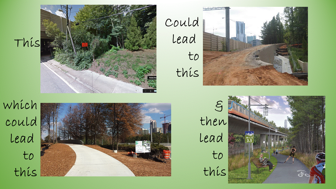
Let’s make room for trails here!
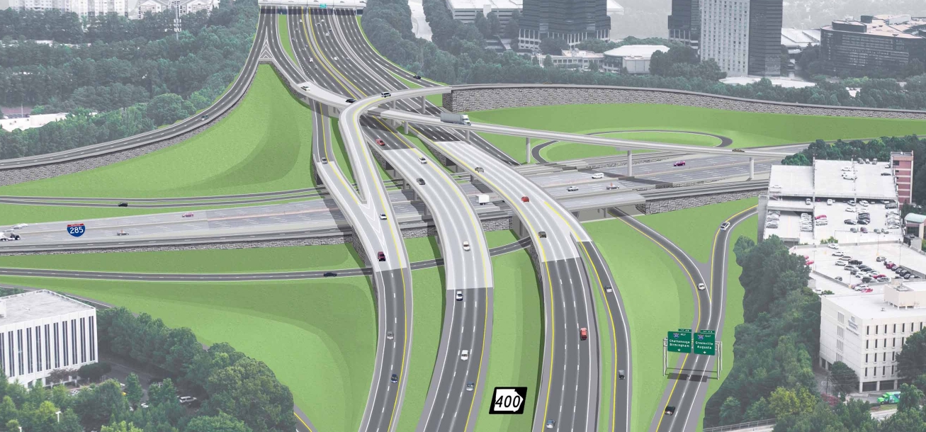
SR-400 Collector-Distributor & I-285/400 Interchange Redesign Projects
Multi-Use Trail & On-Street Facilities Request
On-Street Bicycle Facility Design
Follow the GDOT Complete Street Design Policy & Manual
Please apply the NACTO Urban Bikeway Design Guide (Adopted by the City of Atlanta)
FHWA Support of NACTO Urban Bikeway Design Guide. (Dated 8/20/2013)
FHWA Diverging Diamond Interchange Informational Guide, August, 2014. Chapter 3, Multimodal Considerations. Clearly identifies 3 basic options for accommodating bicycles at a DDI.
Sidepaths have inherent difficulties in built-up urban areas. Need to consider transition areas at the project boundaries. What facilities are existing & planned to connect to the project area? One-way or two-way?
Consider Cycle Tracks / Protected Bike Lanes per the “Green Lane Project” guidelines. See example on 10th Street in Midtown Atlanta.
Multi-Use Trail / Greenway / Separated Bicycle & Pedestrian Facilities
City of Sandy Springs Bike/Ped/Trail Plan: Multi-Use Trail along both 400 & 285
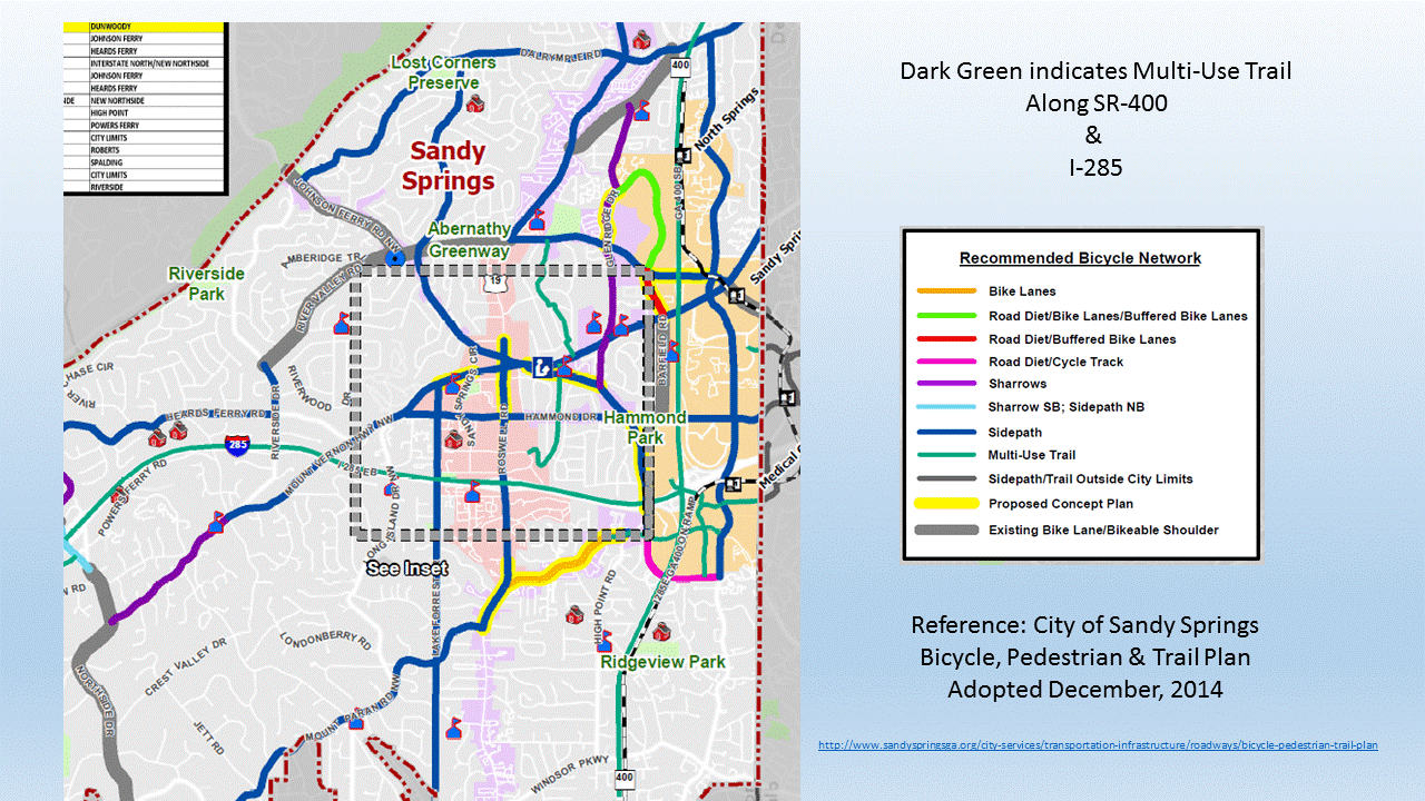
Approved & adopted by their Mayor & City Council in December, 2014. Plan & details click HERE
Georgia Examples:
PATH-400 Multi-Use Trail along SR-400 Right of Way
SR-166 in Carrollton
US 278 west of Rockmart
US Federal Highway References:
I-70 in Colorado, west of Denver
Austin, Texas: Building a bike/ped path as part of the MOPAC highway project. They justified using federal CMAQ funds for it by showing that the completion of the missing link in the bikeway system would reduce congestion on the highway, allowing them to delay or eliminate the need for an additional lane on the highway, which would be way more expensive.
http://austintexas.gov/mopac-bicycle-and-pedestrian-bridge
http://www.mopacexpress.com/enhancements/bike-pedestrian.php
US-36 between Boulder and Denver:
After lengthy process, the final EIS included addition of a separated bikeway running along the entire 18 mile corridor.
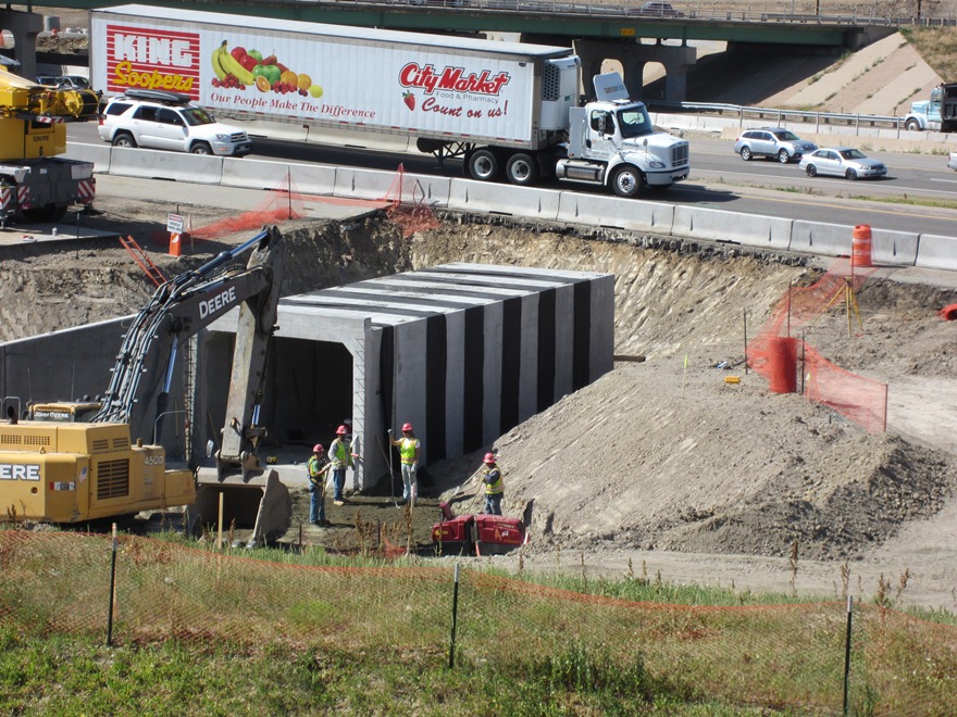
Bike/Pedestrian Underpass Installation over US 36
News article here
Colorado DOT Official Bikeway Construction Website click here
Approved Environmental Impact Statement click here
US-50 Interchange, Sacramento, California
Constructed a continuous bicycle and pedestrian pathway separated from vehicular traffic with grade separated undercrossings at the freeway ramps.
Think of having something like this for the Abernathy / SR-400 Interchange, on the underpass of SR-400. It is proposed that interchange become a “Diverging Diamond”, similar to what is on the Ashford-Dunwoody bridge over I-285.
For the news article, click here
TV coverage of ribbon cutting, click here
Why do we want a separated & dedicated path at Abernathy?

Photo from Copehagenize.com.
A consultant working for GDOT told us that with the current design of the Diverging Diamond, persons on bicycles would dismount & “act as a pedestrian”, sharing the sidewalk to go through the Diverging Diamond…. Hmmmm.
Please take a few minutes to review this video of Charles Marohn of Strong Towns narrating a “response” to an engineer’s tour of the pedestrian & bicycle features of a Diverging Diamond Interchange. The current GDOT design for persons on foot or on bicycle is nearly the same as in this video. After watching this, do you think you’d be comfortable?
Do you think GDOT can do better than this to provide a safe & comfortable experience for people on foot or by bicycle? We think so.
I-580 Richmond-San Rafel Bridge, Marin County California
Proposed 10-foot-wide bi-directional pedestrian and bicycle pathway receives unanimous vote of approval on 2/11/15 by the Bay Area Toll Authority.
For the news article, click here
FHWA Guidance: Under the United States Department of Transportation Policy Statement on Bicycle and Pedestrian accommodation:
“The DOT policy is to incorporate safe and convenient walking and bicycling facilities into transportation projects. Every transportation agency, including DOT, has the responsibility to improve conditions and opportunities for walking and bicycling and to integrate walking and bicycling into their transportation systems. Because of the numerous individual and community benefits that walking and bicycling provide – including health, safety, environmental, transportation, and quality of life – transportation agencies are encouraged to go beyond minimum standards to provide safe and convenient facilities for these modes.”
Can’t Afford Not to: Dedicated Bicycle & Trail Accommodations add value to local businesses & homes. Improve Health, Increase local transportation options. All adds up to an excellent long-term Return on Investment.
Safe Routes to Transit: Allow Non-Motorized access from MARTA stations to employment centers, providing a SAFE transportation option, relieving local motor vehicle rush-hour traffic.
Plan for the Future: Bridges last 50+ years. Millennials are looking for walkable, bikeable communities & will relocate their businesses & create new jobs where this infrastructure exists. This trend will increase.
Regional Connected Network: PATH400 Trail is being built northward along GA-400 up to the Sandy Springs city limits. Roswell trail system connects into Alpharetta with plans to connect into the Forsyth County trail network. is the single point of access between Perimeter CID, Dunwoody, Sandy Springs to cross the Chattahoochee River into Roswell, connecting into their trail & bike network and points beyond.
Supports Existing Plans: Perimeter CIDs Commuter Trail Plan, DeKalb County 2000 Trail Plan, Sandy Springs 2014 Bike/Ped Trail Plan, Dunwoody Comprehensive Land Use Plan and City of Brookhaven plans reference connection to regional trail networks. Chamblee & Dunwoody planning to conduct an LCI Study of the 285 corridor, including Multi-Modal transportation. Connectivity to Doraville former GM Plant for Live-Work-Play.
Revive 285 designates Multi-Modal transportation options along these corridors.
Eric Robert