
About
This page is a placeholder for the ongoing study, design, approval, funding and ultimately building of bicycle and pedestrian infrastructure on Hammond Drive between Glenridge Drive and Ashford-Dunwoody. The area spans both Sandy Springs and Dunwoody cities and is in close coordination with the Perimeter Community Improvement Districts organization.
The FIRST TIME the pubic will be able to formally see the design and offer input is on Thursday, April 21st from 6-8 pm at Dunwoody City Hall.
Please RSVP. Click HERE.
Summary
We totally commend the cities of Sandy Springs, Dunwoody and the Perimeter Community Improvement Districts for seriously entertaining creating a safe & connected network for persons to move around outside of their privately-owned motor driving machines. For working on REDUCING motor vehicle miles traveled, cleaning our air and helping increase public health. Seeing facilities that are separated for pedestrians, and separated with a buffer / barrier for persons on bicycles is the highest safety standard of which to strive. And this project incorporates much of that,
But. There’s a few things that can be modified to insure even greater safety for humans to move around on this corridor once they are outside of their cars. Please take a few minutes to read on.
Our Three Bottom Lines for this project:
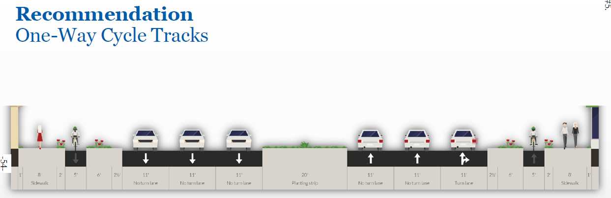
- Install One-Way Cycle tracks in both directions along the entire corridor
- Keep Pedestrians & Bicyclists Separated
- Reduce vehicle lane widths from 11 feet to 10 feet
11/14/2016 UPDATE:
Good News! On November 11th, the Dunwoody Public Works Director presented to our city council the updated plan. Based on public input and feedback, it includes:
- One-Way Cycle tracks in both directions along the entire corridor
- Keeps Pedestrians & Bicyclists Separated
For the plan details, please click HERE on Councilman John Heneghan’s Blog.
The next questions would be WHEN will this project be done, and HOW will it get paid? That is the gorilla in the room. As new developers come in and build anything along this corridor, they will be expected to build their segment. We heard the timeline could be from five to ten years to see this to fruition. To that we say agggh!! And if you WANT to see this built sooner, let your elected officials know and get them to commit to a much quicker timeline.
PS: How did “we” find out about this revised plan? By reviewing EVERY city council agenda. Every time they meet throughout the year, we review the agenda. Generally, for the Monday night council meetings, the agendas are posted the Friday beforehand. So that leaves the weekend to muster the troops — if needed and to show up & speak out.
Part I (a) – Public Input / Feedback Mechanism
As private citizens or as a civic organization, we at Bike Walk Dunwoody have not been invited as a stakeholder to have initial review and feedback into this plan. We obtained the proposed plan posted to the City of Sandy Springs website as a council agenda item. Presently, there are no means to offer feedback except to email Sandy Springs and Dunwoody Public Works.
Part I (b) – Public Open House: 4/21/2016
The FIRST TIME the pubic will be able to formally see the design and offer input is on Thursday, April 21st from 6-8 pm at Dunwoody City Hall. We’ve been told that it will be more of an Open House, where attendees can walk around, ask questions and offer input.
*** It is SO IMPORTANT that you take the time out to attend and provide your feedback ***
Dunwoody City Hall
41 Perimeter Center East, Dunwoody, GA 30346
Part II – Sandy Springs Meeting (3/15/16)
The Sandy Springs Reporter covered a story that on March 15, 2016 the Sandy Springs City Council held a Work Session that included a presentation by the design consultants and their staff on a proposed design of Hammond Drive for bicycle & pedestrian improvements. That’s where we found out about this. For the story, click HERE.
Part III — The Design that needs to be fixed (as of 4/18/2016)
Transitions are EXTREMELY DANGEROUS, especially when the cycle track changes from one-way to two-way. And, a multi-use trail in an urban environment is also NOT preferable. Not only are transitions inconvenient, but they require even more use of crosswalks. And, bicycles are not legally allowed in crosswalks. (This is also why multi-use trails in an urban environment are not preferable.) The only legal way to use a cross walk is to dismount and push – which we know nobody is going to do. We don’t think we should be building infrastructure which is almost impossible to use in a legal manner.
Transition points at the end of facilities are a big issue. Where do you go at the end? How do you go across the street?
Have to jump over and cross the street at one point to continue going in the same direction. Seriously?
Don’t mix pedestrians with persons on bicycles in a built-up urban environment.
Each driveway, curbcut and intersection are the most dangerous places. Especially when a person on a faster-moving vehicle such as a bicycle is moving in the OPPOSITE direction of motor vehicle travel. Ideally, persons on bicycles need to be moving predictably – in the SAME direction as motor vehicle traffic.
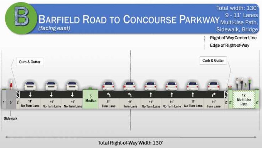
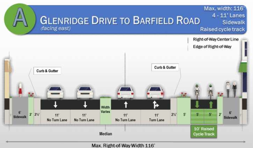
Look at the design below between Barfield & Concourse. Does it look safe & inviting for persons on foot, on bicycle or in a wheelchair? 130 feet of Right-of-way. 99 of those feet are for the exclusive use of motor vehicles. And why are we mixing persons on foot with persons on bicycles on the same facility?
Reduce 11-ft width of motor-vehicle travel lanes to 10-ft
There are NINE (9) motor vehicle lanes at 11-feet wide in this segment. Simply reduce the lane width to 10-feet and — amazingly –this will free up NINE FEET of already-existing pavement between the curbs. That’s lots of room to work with in building out protected bike lanes that are separated from motor vehicles — and — separated from persons on foot, too.
Georgia DOT Says, “10-ft Lanes on Peachtree Road”
If our own state department of transportation is designing 10-foot wide motor vehicle travel lanes on streets with over 40,000 vehicles per day, so can we.
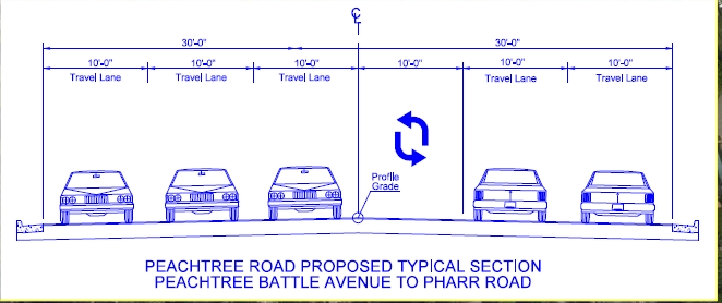
Narrower traffic lane widths of 10-ft calm traffic and increase safety for drivers, pedestrians and persons on bicycles. Additional NACTO reference, click HERE.
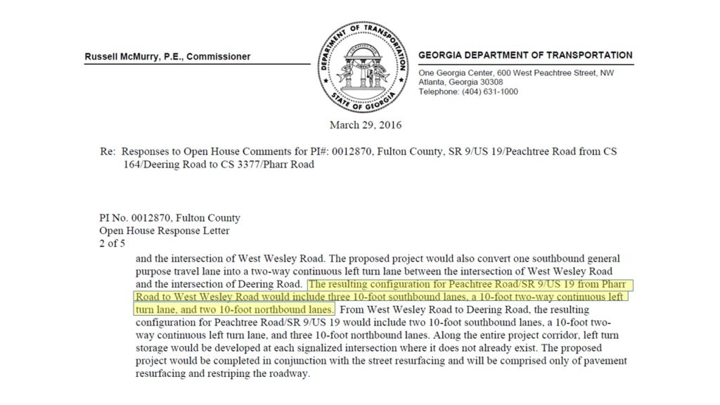
Download GDOT Letter, click HERE.
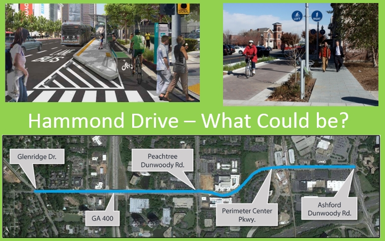
We can do better.
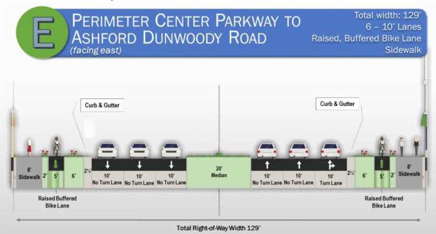
Like this segment below as proposed between Peachtree-Dunwoody and Perimeter Center Parkway. This includes: Raised & buffered one-way 5-ft bike lanes (cycle tracks), and separate, 8-ft wide sidewalks along both sides of the street. Not only does this look pretty awesome, it’s also the SAFEST.
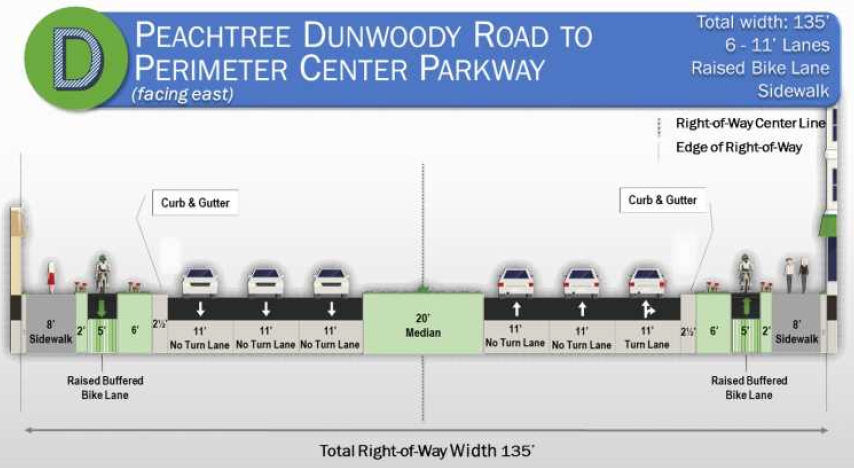
Doesn’t this look AWESOME??? We think so.
Part IV — Recommendations (as of 4/18/16)
For starters, here’s a few points to consider:
- We strongly urge the design to follow the NATCO Urban Street Design Guide.
- Reduce motor vehicle travel lane widths from 11-feet to 10-feet. Is allowed by AASHTO and studies have shown there are no negative vehicle throughout effects. And GDOT is doing this for Peachtree Road in Buckhead. This will allow for a calmer, safer street for motorists, pedestrians and disabled.
- Use separate facilities for pedestrians and bicycles. Very dangerous in a busy, built-up urban area to mix these uses. See NACTO guidelines for design best-practices.
- Keep the same facility consistent along the same side of the road along the entire street. We can’t expect someone to be on one side of the street to stop; go to the nearest crosswalk; cross over; and then continue to proceed in the same direction. That is what is presently proposed.
- How will each traffic light crossing be designed? Especially when people have to move across the other side to continue moving in the same direction.
Transitions for persons on bicycles – take a trip
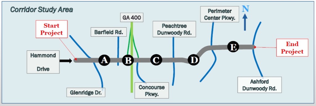
Let’s take a trip and imagine riding your bike eastbound starting over on Glenridge and going to Ashford-Dunwoody. (Never mind trying to figure out how you’d get to work in the Concourse, which is on the opposite side of the 9-lane “highway” of the trail)
Part A: Glenridge to Barfield (2-way cycle track on the north side / westbound traffic for cars)
First you have to cross over on the westbound (opposite) direction of motor vehicle travel and get on the 2-way cycle track. Watch over your shoulder to the right for any cars trying to make a left-hand turn into any locations to your left (behind your back). You’ll also be passing other persons on bikes headed in the opposite direction back west from where you started.
Part B: Barfield to Concourse Parkway (12-ft Shared Use Sidepath)
Once you cross the intersection at Barfield, you now find yourself on a 12-ft wide “Shared Use Path”, intermingling with pedestrians, strollers, wheelchairs and such. Each person can be moving either with or against traffic. This is against NACTO best-practices design.
Do we really need 99-feet of 11-ft wide vehicle travel lanes for motorized driving machines?
Part C: Concourse Parkway to Peachtree Dunwoody (2-way cycle track on the north side / westbound traffic for cars AND 5-ft bike lane on the south side / east bound)
If you’ve already been on the shared use path on the north side, then once crossing Concourse Parkway, you’d go back into a separated & dedicated space, just like it was between Glenridge to Barfield. Or, say if your final destination was on the south side of Hammond, you could cross the street at the intersection with Concourse Parkway and get on the 1-way bike lane; allowing you to move in the same direction of motor vehicle traffic. [Note: It’s very interesting that the design added this 1-way cycle track. It’ll connect into the FUNDED and to-be-built 2-way cycle track that will run north along Peachtree Dunwoody from I-285 .. and eventually to the PATH400 trail..and eventually to the Beltline…]
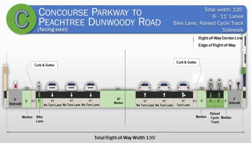
Part D: Peachtree Dunwoody to Perimeter Center Parkway
If you had stayed on the north side of Hammond Drive along Part C in the raised 2-way cycle track, now you’re STUCK. You’ve been hit with a penalty for not being in a car. You have to first cross at the intersection at Peachtree Dunwoody, get to the south side and THEN you can continue traveling eastbound. How does this make sense? Do motorists have to stop, get out of their cars, push a crossing “beg” button to continue moving in the same direction?
Part E: Perimeter Center Parkway to Ashford-Dunwoody
Since you already moved over to the southside of the street at Peachtree-Dunwoody, you’re fine and can continue on your way.
Part V – More Questions
We’ve asked for more information, and that it be published on-line in advance of the PIOH. If we get a response, we’ll update it here.
We feel it’s important to know more about the current design and how it came to be. Consider asking at the Open House on Thursday night, as well (And get a business card / contact info with whomever you speak with and please follow up).
- Where are the Project Alternatives? Expecting to see “A”, “B”, C” with pros & cons. The concept document shows a single set of recommendations for the entire corridor. Per the Fact Sheet, it states alternative options were to be prepared. The cycle track is listed as Option 5. Hmmmm???
- Project selection criteria matrix that shows the presented solution has the highest rating.
- Who are the stakeholders are that participated in the design to this stage? Did it include any citizen advocacy organizations, PEDS Atlanta, PATH Foundation, etc.?
- Motor Vehicle traffic counts by section as defined in the concept doc: A, B, C, D, E. The hand out offers a range from 16k to 27k along the entire corridor.
- Do the segments A-E require additional right-of-way? Does it require moving curb & gutter?
- Is there a build/construct timeline and budget estimates?
- Who will be the final approvers of the project design and when is this scheduled to take place? Will the public be notified prior to such votes?
Lastly, allow for an on-line feedback mechanism for public to offer input.
Part VI – References
3/15/2016 Design Presentation to Sandy Springs City Council
Click here to download the two PDF documents that show the above images, and an information sheet.
Dunwoody
Public Works has project information and similar documents posted on their website (HERE). It states: