
We’re sending out a big thanks out to the City of Dunwoody, Grubb Properties and the Perimeter Community Improvement Districts for funding another “tooth” in our Dunwoody Trailway network!
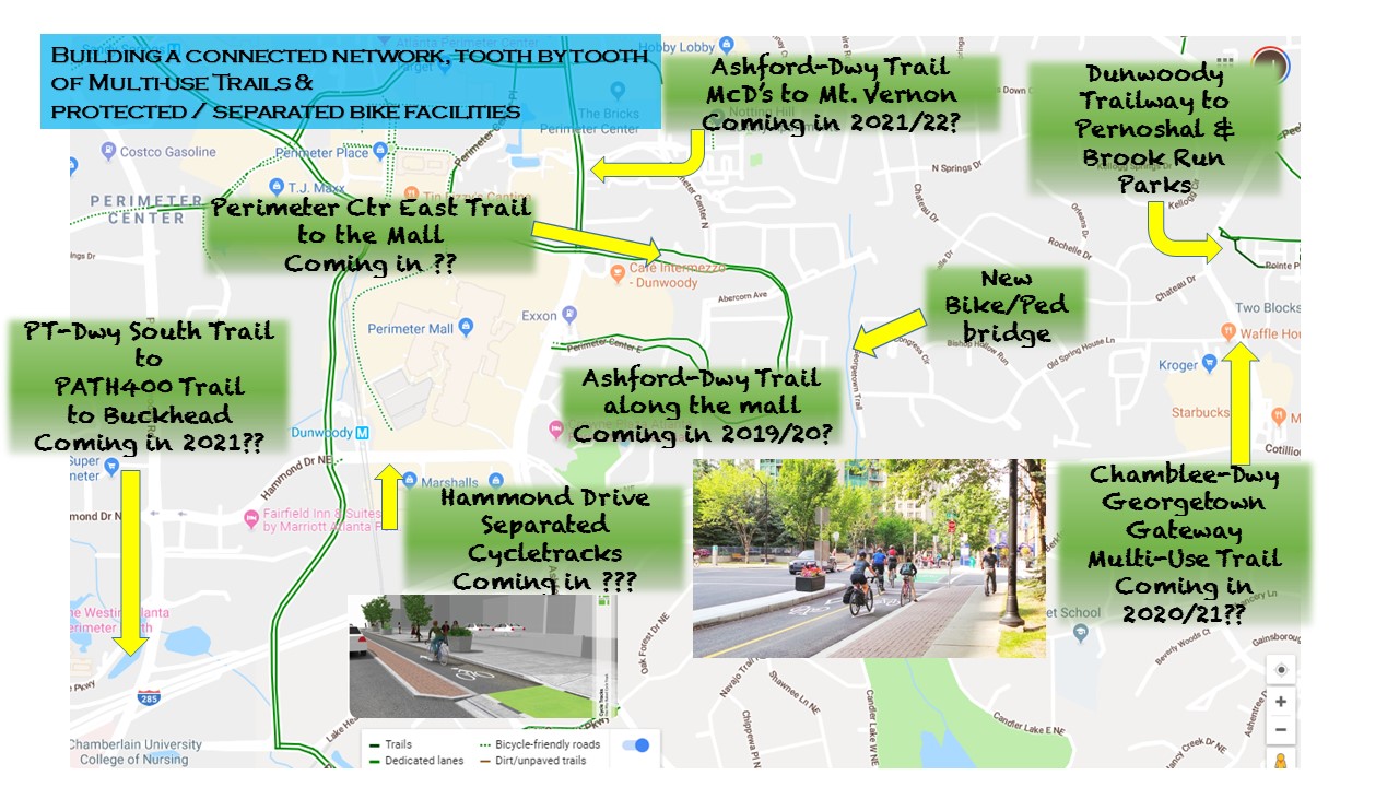
Grubb Properties has agreed to fund up to $225,000 towards the design and construction of a multi-use trail along Perimeter Center East to Ashford Dunwoody. This will provide separated, off-street bike connectivity from the NEWLY BUILT trail and bridge on Perimeter Center East behind the new townhomes, which crosses the North Fork of Nancy Creek, goes to Old Springhouse Lane into the Georgetown residential neighborhood. Story here.
What’s today?
Today there’s the trail in Brook Run, that runs westward to Pernoshal Park on North Shallowford. The trail continues across North Shallowford to Georgetown Park, to Chamblee Dunwoody. If you care to, take the sidewalk on Chamblee Dunwoody to the Waffle House and turn right at the light on Old Springhouse Lane. It’s almost all DOWNHILL to the bridge. If you’re riding a bike, we recommend you ride with traffic in a “predictable” fashion; defensively, but confidently. Remember it’s posted at 25 mph. So encourage your motorist friends to obey the speed limit. At the bottom, take the bridge, ride on the trail up to Perimeter Center East, and take the bike lanes either way. Maybe stop at Cafe Intermezzo or Alon’s for a bite to eat? — Be sure to bring a bike lock. There’s a single inverted “U” bike rack in front of Alon’s (Yours truly at Bike Walk Dunwoody helped arrange that a few years ago). If you turn right from the trail onto Perimeter Center East, and go to Ashford Dunwoody, going straight (past McDonalds — towards Tin Lizzy’s) it’ll take you to the bike lanes on Perimeter Center West. Turn right and you’ll begin the incline on a 4-ft wide paved shoulder (same width as a basic bike lane) on Ashford Dunwoody. If you turn right on Ashford Center Parkway to get to Womack / Chamblee Dunwoody, which connects to those bike lanes. Or head straight up, burning some more calories and feeling the quads burn a little, to Mount Vernon. Where you’ll also find bike lanes. Checkout Google Maps, and turn on the Bicycling layer to see where most of the bike lanes are located in Dunwoody.
What’s paid for and really happening next? Our best guess
1: Multi-Use Trail in front of Perimeter Mall along Ashford Dunwoody between Hammond Drive & Perimeter Center West. Look for construction to happen in 2020. Story here. Plans here.
2: PATH400 Trail access under & around the 285/400 Interchange. Will run along the west side of Peachtree Dunwoody under 285, loop around between Northside / St. Joseph’s hospital and 400, and go to Johnson Ferry. Funded between the PATH Foundation & City of Sandy Springs. Best guess is this will be finished when the interchange is nearing completion. Want to learn the history of how this came to fruition? Back in 2014 GDOT was holding Public Information Open Houses, as a checkbox to spending nearly a Billion dollars on these car-only projects. Bike Walk Dunwoody ran a months long campaign to get GDOT to provide this trail accommodation. Got resolutions of support from the top-end 285 cities, civic and business organizations to support. Did a TON of research and presenting examples. Attended many meetings. Then, our friends at the PATH Foundation held meetings with GDOT, Sandy Springs and others. And it became reality. All of the history from 2014 – 2015 is posted here.
What’s being DESIGNED, that will get built in the next 2-4 years?
1: PATH400 trail from Johnson Ferry southward to the Atlanta City limit.
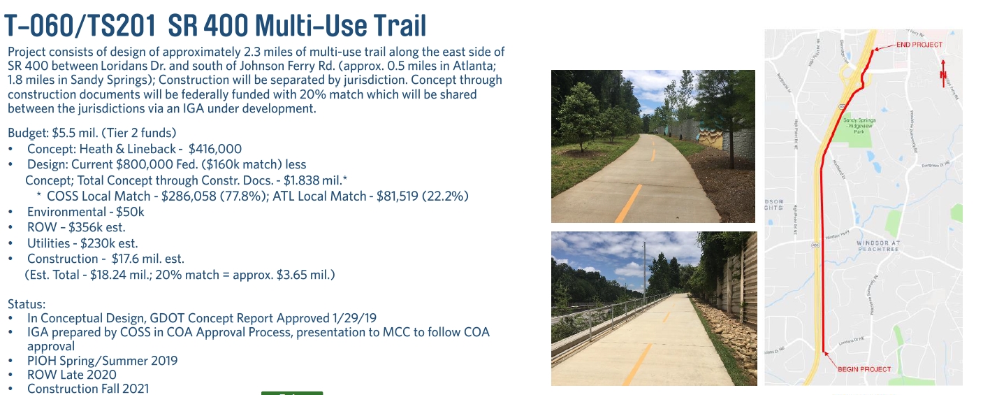
Trail being paid for by the Fulton County TSPLOST. Managed & implemented by the City of Sandy Springs. This is identified as a “Tier II” project with a forecasted budget of $5.5M. Targeted for construction in 2021. (Note: PATH400 in Buckhead has to be extended by the City of Atlanta northward by almost a mile to the Sandy Springs border. Lot’s of variables). Sandy Springs project details posted here. March, 2019 Sandy Springs TSPLOST program update posted here.
2: Ashford Dunwoody trail from Perimeter Center West (McDonald’s) to Mount Vernon. In December, 2018 the City of Dunwoody council approved funding engineering & design. Realistically, this is going to cost $$$ and will take time. First, there’s a ton of existing infrastructure that will need to be surveyed. Lots of impact in moving street lights, utility poles, drainage, sidewalks, and acquiring easements. Just ask our friends in Buckhead with the PATH400 about what they’ve encountered. Secondly, the city — meaning we as citizens that VOTE — need to figure out if we’re going to only “pay as you go”, or to finally issue bonds to invest today. If we “pay as we go“, then I could see this not being built for at least another five years. So we’re talking 2024. If we follow Brookhaven’s lead and issue a bond against the Hotel/Motel tax (only requires a council vote), we could start building this in 2020. Reference here.
3: Chamblee Dunwoody Gateway. Basically from 285 up to Peeler/North Shallowford. City has funded & approved $700k in FY2018. Targeted to “Begin Construction” in 2019. What’s going to be constructed? Not precisely sure. We’ll know once a contractor has been selected and the council will vote to approve the contract. We know there’s going to be a multi-use trail along this segment. This would then connect into the existing trail network to Brook Run. BTW, in 2015 when these designs were being presented to the public, your friends at Bike Walk Dunwoody fought the good fight and really, really tried to get separate pedestrian and separate bicycle facilities here. We tried to keep the bike traffic separate from the pedestrians, dog walkers, baby strollers and such. We tried to keep the bikes ONLY moving in the SAME DIRECTION AS TRAFFIC. As that’s the SAFEST, world-class best practice design. But it didn’t happen. Want to see what we presented, with images and references? Go here.
What’s more vague?
1: Hammond Drive from Ashford Dunwoody to Peachtree Dunwoody. Being built out piecemeal as new developments come in. Not precisely certain when this will be fully built out. Crosses from Dunwoody into Sandy Springs. BUT, we do know that thanks to the campaign led by Bike Walk Dunwoody in 2016, we were able to change the initial project proposal into safe, seamless facilities along the entire corridor. Initially, they were going to have trails (mixing peds/bikes/dogs/etc. going bi-directional in the same shared space.). Some on the south side of Hammond, and then you’d have to change over to the north side after a while. It wasn’t very nice. We mobilized, attended the Public Information Open House, sent emails and made a difference. Now, we’ll have pedestrians on wide sidewalks, and folks on bikes – a) Riding in the same direction as traffic; b) in their own space; c) with a physically separated barrier from motorized traffic. HOORAY!! For reference, click here to learn how we made it happen in 2016.
Bottom Line?
It takes a LONG time to see a GOOD plan approved, get funding, get it designed & engineered and finally built.
What can you do to help make a difference?
1: Volunteer to help out Bike Walk Dunwoody 2-4 hours a month. Go here to sign up.
2: Sign up to the City’s email list. Review the council’s agendas when they are posted online on Fridays. If there’s anything to do about bike/ped, rally the troops, send emails to council, come to the Monday night meetings (6 pm), sign up for Public Comments before the meeting starts, & speak out.
3: Watch for Public Information Open House meetings for redevelopment plans, etc. Attend them, or at least email your feedback. As of today (3/14/2019), these notices are legally advertised in hard copy in the Dunwoody Crier. So before you toss it in the recycling bin, glean through & look for these notices. Usually it’s a 1/4 page text-only ad.
4: Checkout this blog post at BicyclingJoe.Info that lists ways of keeping informed and getting involved in Dunwoody. Including links to sign up.
Pingback: Another Tooth in the Dunwoody Trailway Network - The Aha! Connection