Hi Friends,
This is gonna be brief. You know the drill. 2017 Transportation Plan Update is being voted on this Monday night. Multi-Use Trails have been REMOVED from the plan.
Call to Action: Attend City Council meeting Monday night 8/14 and speak during Public Comments to SAVE Dunwoody Trails. Arrive promptly by 5:45 pm. Grab a 3×5 Public Comment card, fill it out & hand it in to the city clerk BEFORE 6 pm. Have an outline. Speak from your heart. You get three minutes. Get a baby sitter. Carpool. Bring the kids. Call in sick. Do whatever you have to do show up. Why? Because those that simply SHOW UP get heard; get counted; make a difference.
Still can’t make it? Send a quick email to [email protected] and cc: [email protected]; [email protected]
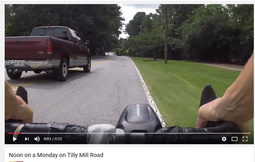
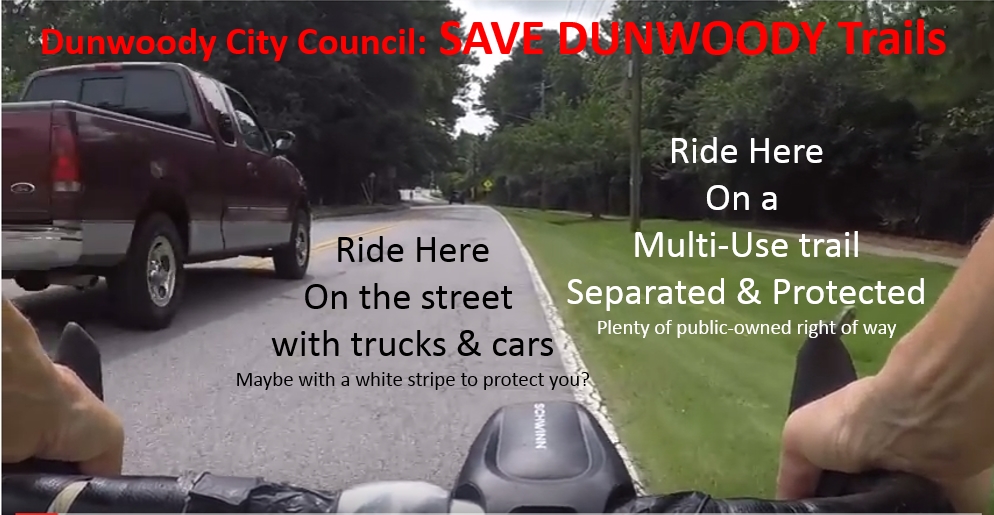
Is this acceptable for Dunwoody Moms? Is this safe & inviting for children to ride their bike to school?
We still have to show up & sound off periodically to add & keep high-quality safe designs for bike & pedestrian facilities. Our Master Transportation Plan – originally approved in 2011 — has gone through an update. Bike & Ped advocates had a great chance to offer input & feedback. We said it’d be great to have a multi-use trail along Peeler / Tilly Mill connecting Brook Run over to Windward Hollow. Also on Tilly Mill from Womack to Mt. Vernon. The plan was presented to council on July 30th. Had pushback from a couple of counciliors that didn’t want them. Two weeks later — August 14th — and the Multi-Use Trails have been REMOVED from the updated plan. They’re been replaced by an ambiguous “Multi-Modal” terminology. “…that includes SOME TYPE of bicycle and pedestrian accommodations”.
![]()
Wow. Really? Seriously??? What does “SOME TYPE mean? Sidewalk & sharrows? Sidewalk and bike lanes?
Since incorporation, the citizens of Dunwoody have spoken clearly: We want more multi-use trails & greenways. We want to CONNECT our parks. We want separated facilities so our children, parents, retirees and casual users can take a bike ride, walk or stroll. We need more than just a white stripe painted on the road. Yes, bike lanes are great where there is no paved shoulder and good for “Type A” Rider. But we also need to commit to serving a greater segment of our residents of Type B & C riders (see below).
Here’s three officially approved Dunwoody city documents that support how we can SAVE DUNWOODY Trails:
- 2011 Comprehensive Transportation Plan
- 2011 Parks Plan – Section 6 Facilities
- 2013 & 2015 Community Survey
To put it in more human terms, please read this post by own Pattie Baker
“Dear City Leaders: If you vote for this plan, please do not pretend that the baby I saw in a stroller at Brook Run Park today will be able to ride his bike safely to the middle school or high school after he can no longer ride his bike legally on the sidewalk. Please do not pretend that the senior on an e-bike will be able to ride to the supermarket or city hall. Please do not pretend that the person in a wheelchair with the hand–bike attachment will be able to go to the mall or the medical center. Please do not pretend that the surging Millennial workforce in this city that shares the claim to the largest concentration of Fortune 500 headquarters in the southeastern United States will have commuting options beyond the automobile if they live locally. Please do not pretend that this is a family or business-friendly city. Please do not pretend you are anticipating and preparing for the future.”
#1: 2011 Comprehensive Transportation Plan:
Issues and Opportunities (PDF page 53)
Connecting neighborhoods through trails and pathway allows for increased opportunities for residents to engage in recreational walking and biking throughout the City without having to access main automobile travel routes. In some cases, this could also improve access to commercial nodes and/or schools.
Type B & C Riders – Casual riders & Children prefer designated facilities such as shared use paths. (PDF page 63)
AASHTO recognizes three types of system users to help assist planners and designers in determining impacts of different facilities and conditions.
- Type A: Advanced or experienced riders who use the bike as a primary mode of transportation. Riders are looking for convenience and speed and generally want to take the most direct route to their destinations with minimum delay and detours. These riders are comfortable mixing with vehicle traffic along roadways; however, they prefer sufficient operating space to eliminate the need for passing by either a rider or a vehicle.
- Type B: Basic or less confident adult riders who also are using the bike for transportation purposes to and from destinations; however, they are not comfortable on high-volume, high-speed vehicular roads unless there is ample roadway to allow for easy passing by the vehicle. Riders prefer designated facilities and are comfortable on neighborhood streets and shared use paths.
- Type C: Children riding either on their own or with their parents. Riders will not travel as fast as adults but still desire to reach community destinations, such as schools and recreational facilities, by bike. Residential streets, shared use paths, and streets with well-defined pavement markings between the bicycle and the vehicle can accommodate this type of rider.
Future Path Connection: Brook Run along Tilly Mill / Peeler to Happy Hollow (PDF page 100)
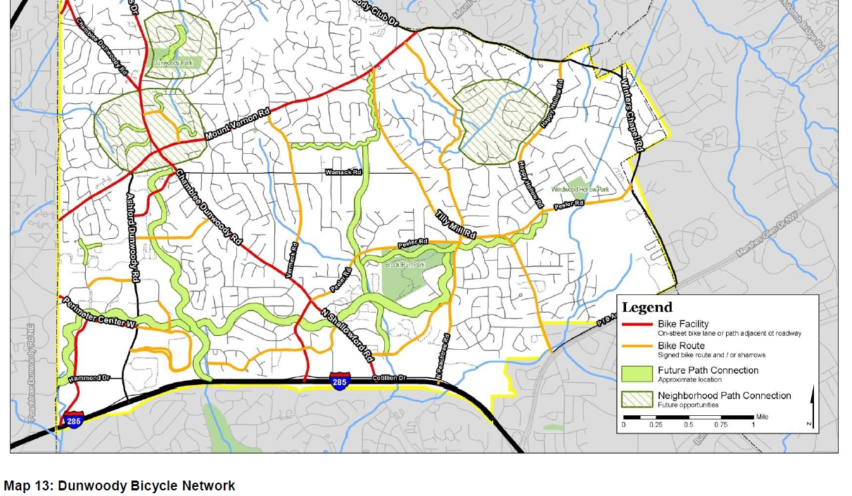
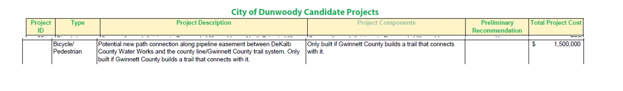
Potential trail to Gwinnett -If Gwinnett builds one. (PDF page 107)
NEWS: Peachtree Corners & Dunwoody is building a multi-use trail along Winters Chapel
#2: 2011 Parks Master Plan – Section 6 – Facilities
Facilities Assessments and Recommendations
“Another way to assemble green space and park land in these highly developed areas is to assemble linear parks or greenways.
SURROUNDING PARKS, TRAILS and PLANNED BIKE ROUTES Figure 6.9 (PDF page 33
Identifies connecting existing parks with proposed greenways
Shows proposed Greenway from Brook Run to Winters Chapel along Peeler / Tilly Mill
Existing and Proposed Greenways Phasing Plan (PDF page 35, figure 6.10)
Peeler Road Greenway Phase I Identified as highest priority 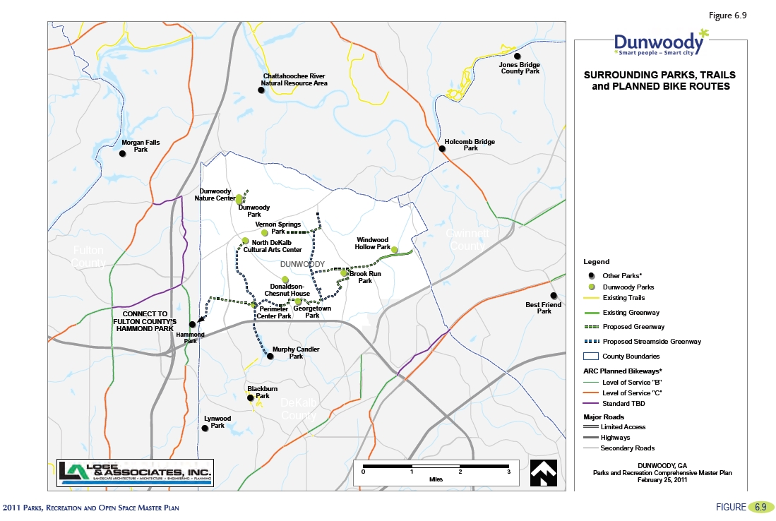
Proposed Parks and Facilities Urban Greenway Corridors
Location: (Perimeter Center and) Peeler Road Greenways
Acreage: Minimal new acreage as greenways will be in roadway rights of ways
Classification: Linear Park/Greenway (PDF page72)
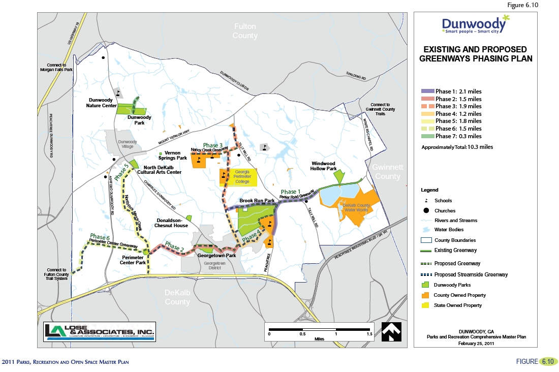
“The Peeler Road Greenway will be an extension of the only greenway that currently exists in the city. Beginning just east of Tilly Mill Road at the western terminus of the existing greenway, the corridor will continue past Brook Run Park and terminate at the Nancy Creek Greenway. The extension will be just 1.5 miles. Because this greenway corridor will be developed in the right–of-way of Peeler Road, we recommend a bike lane be added to Peeler road and a 6’ to 8’ sidewalk be developed parallel to the existing roadway. Like the current trail, we recommend a planting strip of a minimum of 3’ wide be placed between the back of curb and the trail. The trail currently stops just before the intersection of Glaze Drive and Winters Chapel Road. There is an old home site at the intersection of these two roads that would make a great gateway into the city and is large enough to be a trailhead. The City should purchase this property and extend the trail to this location. Additional trailheads for this greenway should be located at Windwood Hollow Park and the intersection with Nancy Creek Greenway. Because the greenway will run through Brook Run Park, the section of trail on the park can be expanded to a full 12’ wide and the park will also function as a trailhead location.”
Note: The existing Greenway referred to runs along the water works on Peeler.
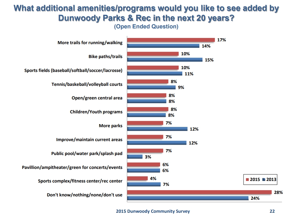
#3 Dunwoody 2015 & 2013 Community Survey:
What additional amenities/programs would you like to see added by Dunwoody Parks & Rec in the next 20 years? (Open Ended Question) (PDF page 22)
Number one response: More trails